The Campus Plan
Adapting in a Dynamic World
It is important to note here that the Campus Plan is primarily a roadmap to help guide the cohesive development of the university’s campus and locations towards a collective vision.
If there is less growth over the next decade, then some of the capital development shown may not be required. The amount of future development will also be dependent on other factors including hybrid work and learning strategies, space utilization rates, and availability of funding. The plan provides an estimation of campus capacity and is a guide to ensure that new infrastructure and renewal projects are implemented in ways that move the university towards this collective vision.
A Revitalized Campus
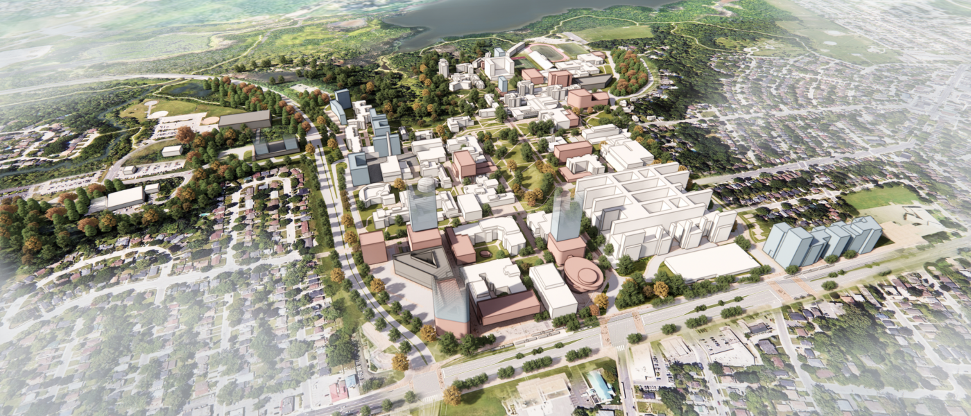
The Campus Plan shows a revitalized campus that provides a vibrant and welcoming environment for students, faculty, staff and the local community. New and refurbished buildings will activate public spaces and provide world-class facilities to support the university’s academic mission. The campus will embrace its outstanding natural surroundings, with enhanced blue and green infrastructure, and the naturalization of key portions of west campus. The removal of most vehicles from the heart of the campus and the pedestrianization of internal streets and spaces to form places for people, alongside the integration of key transit infrastructure, will have a transformational impact on the overall feel of the campus and promote a healthy and inclusive environment focused on physical and mental health and well-being.
The below map identifies the development zones covered within this section.
Note that while McMaster Innovation Park (MIP) is owned by the university, it operates as a separate, for-profit business. As such, detailed plans for the future growth of this site can be found within the McMaster Innovation Park 2019 Master Plan. More information is available on their website: https://mcmasterinnovationpark.ca/
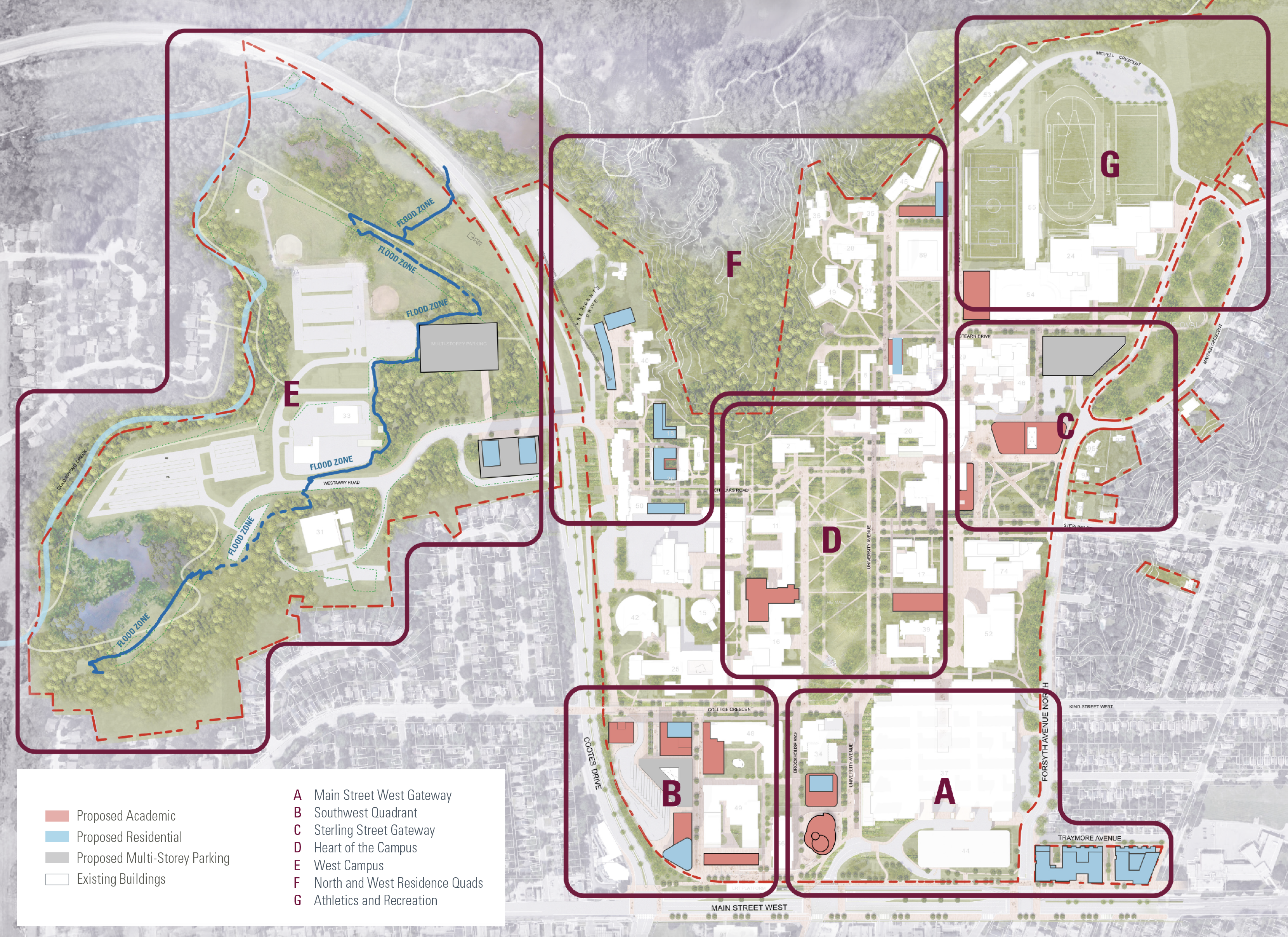
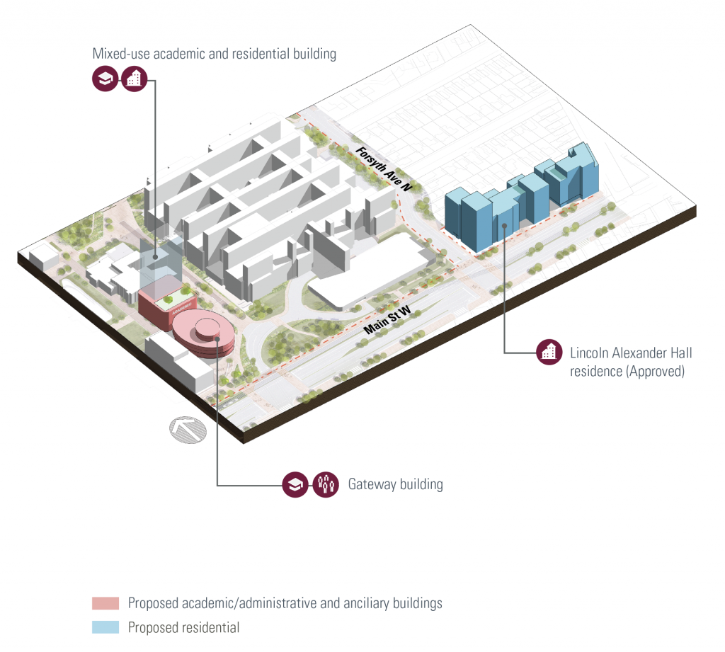
Main Street West Gateway
The vision for the Main Street West gateway includes opportunities for a new iconic signature building with a green outdoor public space that would enhance the current sense of arrival to the university. Opportunity for further mixed-use residential and academic space exists to the north of this site leading to the green mall, to further improve the setting for the hospital.
A remodeled pedestrian-focused and naturalized streetscape is proposed along the Main Street West frontage, integrating pedestrian walkways and cycleways within an improved public realm setting, and creating a vital pedestrian link between the new Lincoln Alexander Hall and the campus. The plan recommends that a signalized intersection be provided at Main and Forsyth to provide a safe connection to the campus for residents.
While the aim is to reduce vehicular traffic through the Main Street West entrance, the plan recognizes the importance of the McMaster Children’s Hospital and protects the operating aspects of the hospital. The Main and Emerson entrance will continue to serve as the primary access for accident & emergency (A&E) vehicles, staff and visitors, as well as one of two entry/exit points to the hospital’s underground parking areas.
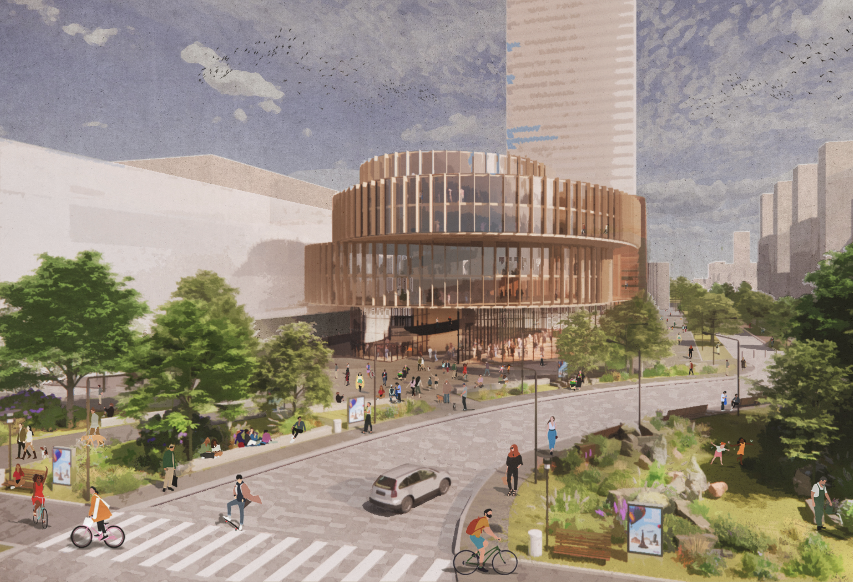
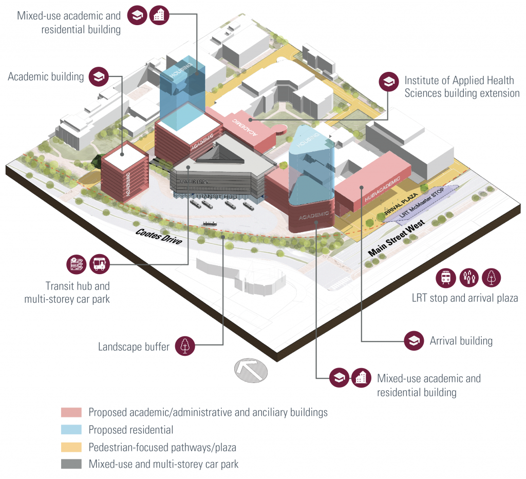
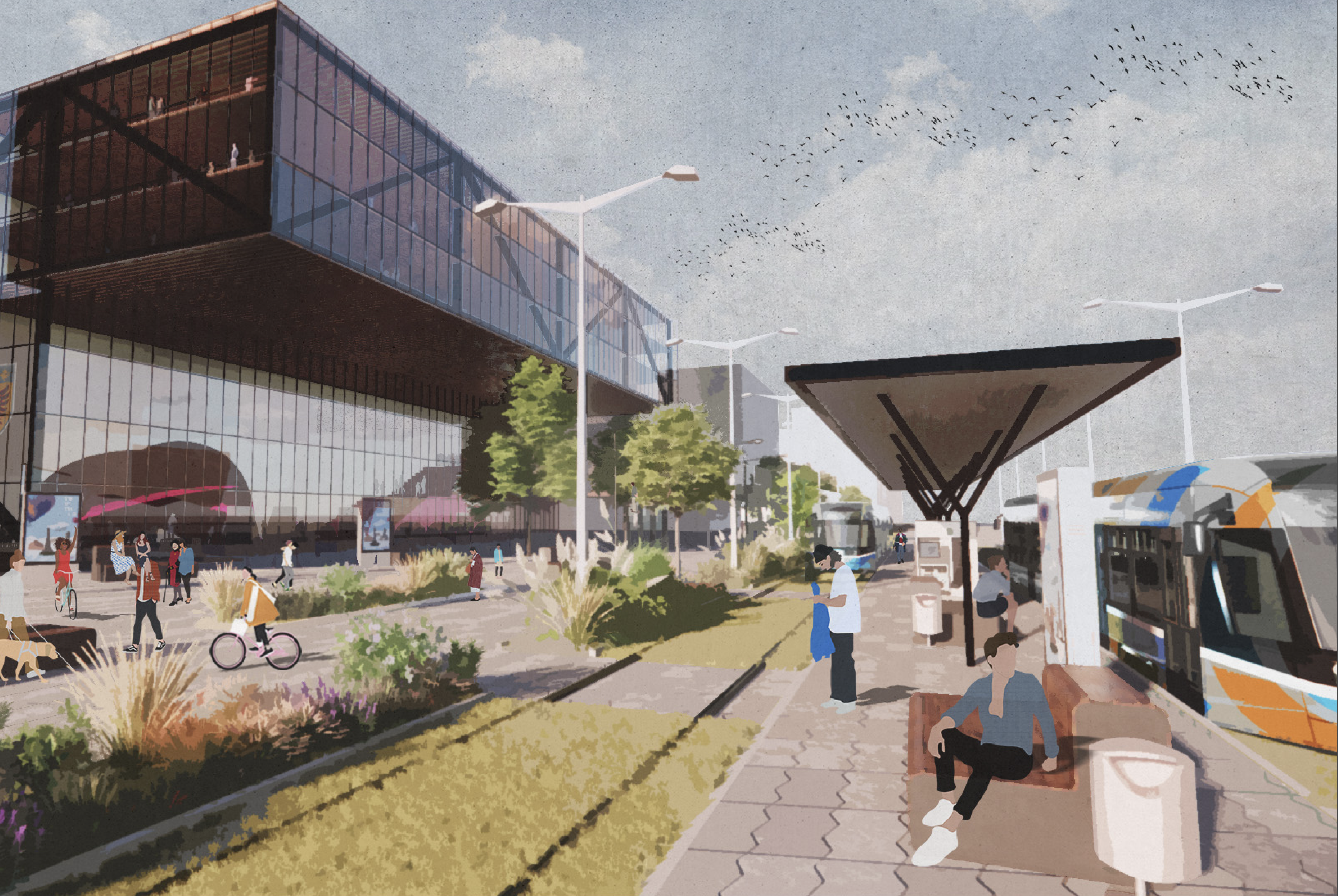
Southwest Quadrant
The southwest corner of the university’s main campus will be home to a new transit hub that will be anchored by the new light rail transit (LRT) connection and include municipal and regional bus transfers, secure bicycle storage and other amenities. Plans to consolidate and re-provide existing parking lot capacity in this area are also being explored, with a structure that is adaptable for other future uses such as living and learning. This partnership project between McMaster, the City of Hamilton and Metrolinx will be the first step towards creating a new arrival point onto campus along Main Street West, encouraging students, staff and visitors to adopt sustainable modes of transportation in an integrated, easy-to-use hub.
The vision for the southwest quadrant also includes opportunities for densification through additions of academic facilities and mixed-use residential buildings with active ground floors. New transit infrastructure and other development will be integrated within a remodelled pedestrian-focused and naturalized streetscape, with a new green plaza proposed between the LRT stop and a new arrival building on Main Street West, and enhanced north-south links providing safe access for pedestrians and cyclists travelling to the inner campus. Student, staff and visitor vehicles will be restricted from entering the inner campus by providing more direct access to parking from Cootes Drive and College Crescent and re-designing interior roads to make it a pedestrian-first environment while allowing paratransit services, individuals requiring accessible car parking and smaller logistics vehicles continued access to campus.
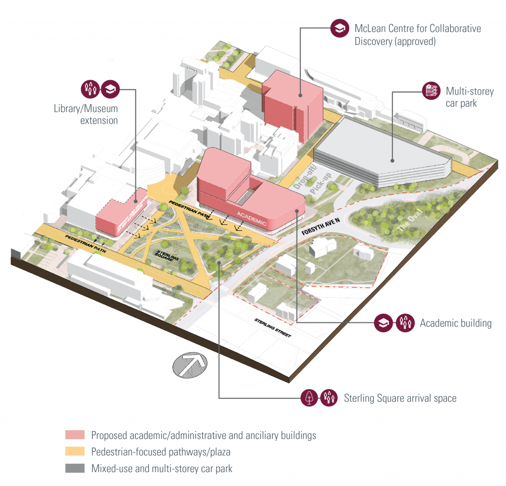
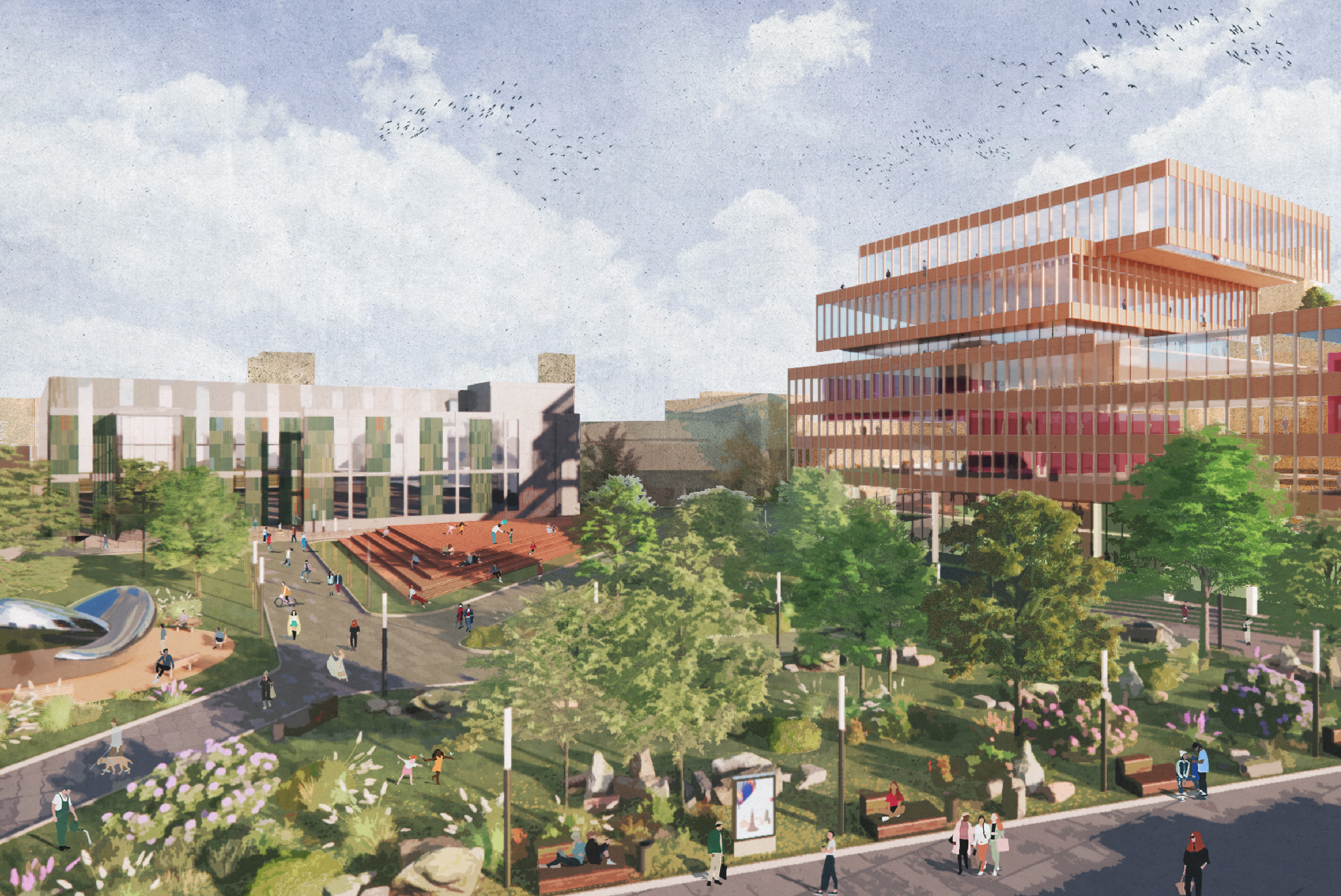
Sterling Street Gateway
The vision for the Sterling Street gateway will provide an attractive new green square, creating a welcoming arrival point from the Westdale neighbourhood. This creates opportunities for new academic buildings or additions facing out onto the square and possibly future expansion to the Mills Memorial Library and the McMaster Museum of Art. A cluster of civic activity in this area creates a focal point for the wider community engaging with facilities and opportunities at McMaster, which should be accessible to people of all ages.
Bringing new buildings to the edge of campus will help engage the neighbours and wider community with the campus by creating a clear edge, replacing the vast surface parking lots and inner network of streets currently on campus.
Vehicle parking can be re-provided in a new consolidated parking structure to the north. Where investment in new car parking is being considered, this should be supported by evidence of demand and a robust financial analysis.
Vehicles entering the campus from Sterling Street would be limited to visitors and permit holders using the L.R. Wilson underground parking and the McMaster Divinity College parking, paratransit services, individuals requiring accessible car parking and smaller logistics vehicles.
The current operations of McMaster Divinity College will remain the same and are not altered by the Campus Plan.
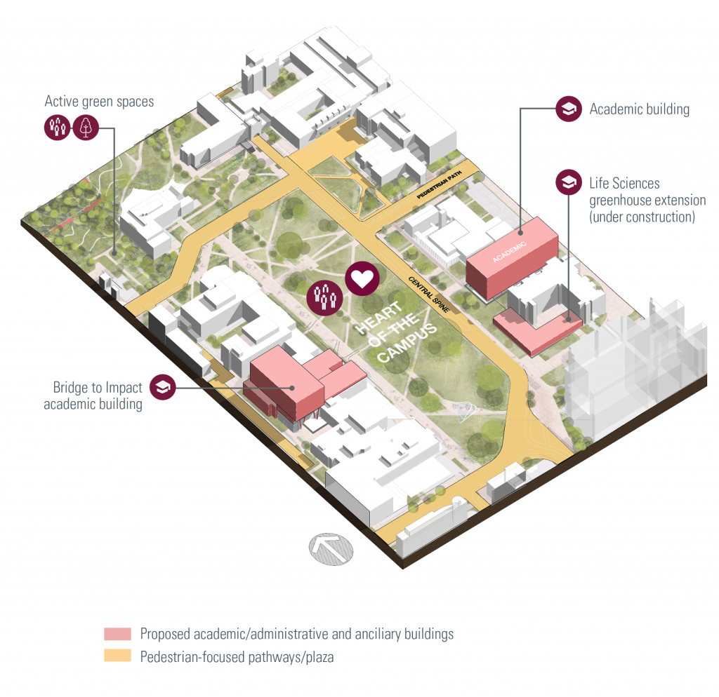
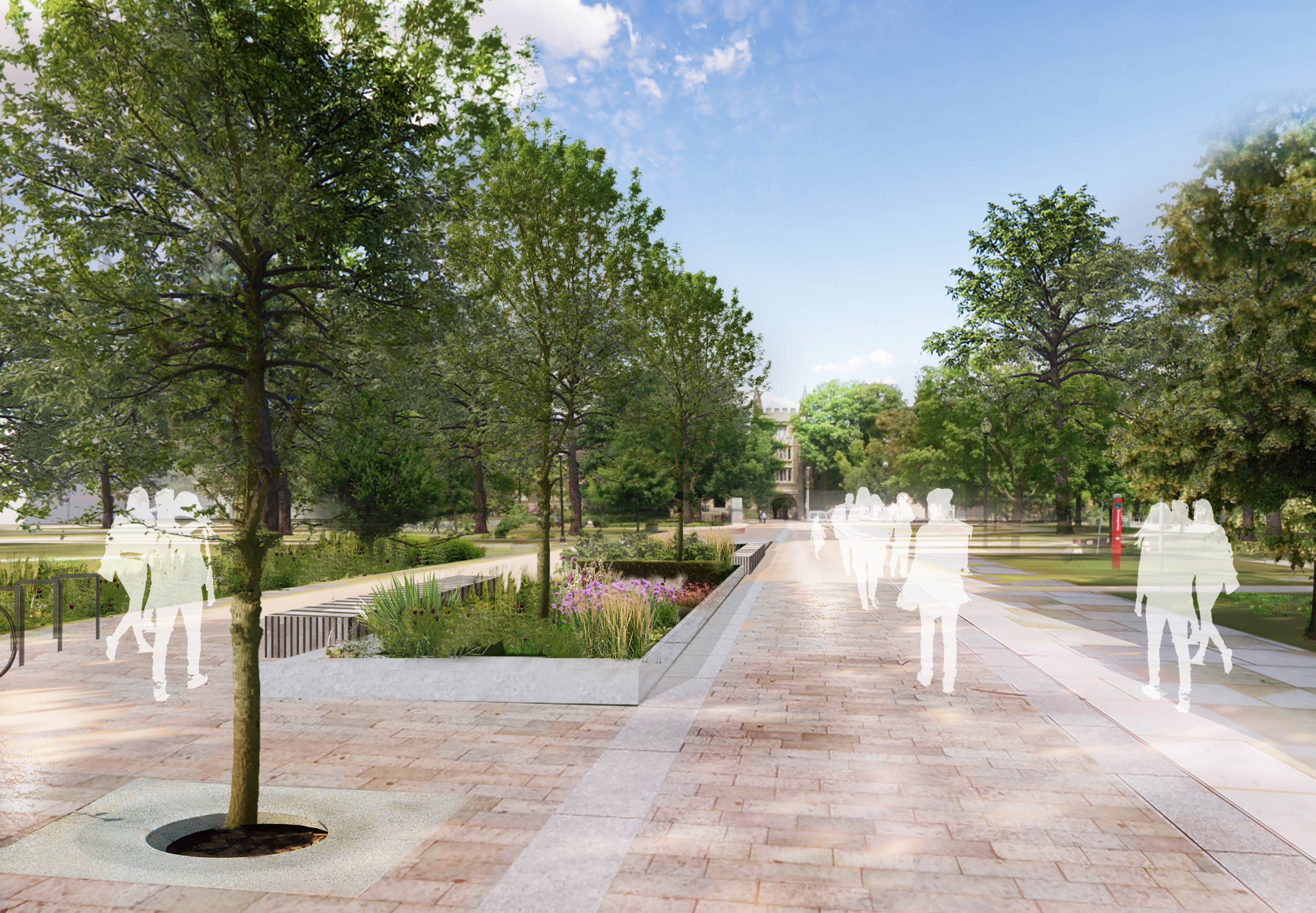
Heart of the Campus
The vision for the heart of the campus includes opportunities for densification and remodelling where possible of ground levels in existing buildings to activate these areas to create open and inviting spaces. This helps to create a more walkable, compact, and sustainable university, creating opportunities to enhance the character of the central campus green and improve other outdoor spaces, while also promoting an age-friendly and inclusive campus through enhanced design of public spaces. The university’s green mall is a key feature of the campus that will be maintained. Within it, there are opportunities for outdoor covered areas as well as spaces to sit and rest or study. Other landscape improvements to the green mall can support objectives from the university’s Sustainability Strategy and encourage active learning opportunities by adding low-impact stormwater features such as swales and rain gardens.
Together with activated ground levels, this public realm will begin to be transformed to provide vibrant spaces that flow seamlessly from interior to exterior.
West Campus
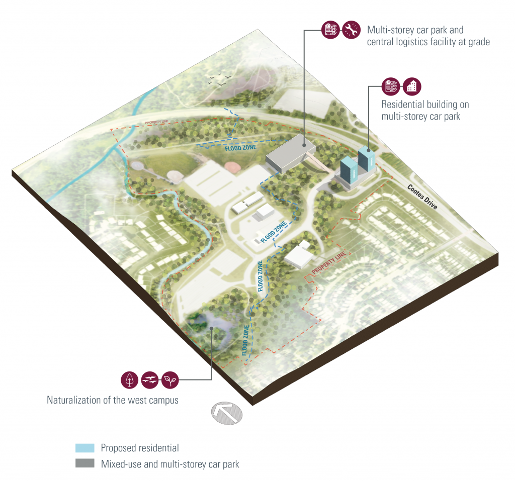
The university’s west campus is nestled within an existing natural corridor linking Cootes Paradise and Dundas Valley conservation areas. The vision for this part of campus is greatly inspired by the Watershed Trust West Campus Redesign Initiative, aimed at safeguarding this biologically rich habitat. Opportunities exist to reclaim a portion of surface Parking Lot M to create a naturalized wetland for research, active learning and recreation. This will enhance the link between the campus and the unique biodiverse ecosystems that surround it and create an environment that supports the physical and mental health and well-being of students, faculty, staff and visitors.
The naturalization process will offer opportunities to support the university’s commitment to Indigenous Reconciliation and collaborative land stewardship.
An updated survey of the west campus indicated that a large portion of this area sits below the floodplain, guiding any new or expanded development within these zones. Protection and stewardship of these areas will be prioritized.
Potential options for parking capacity to be consolidated are considered in areas closer to Cootes Drive and the main campus.

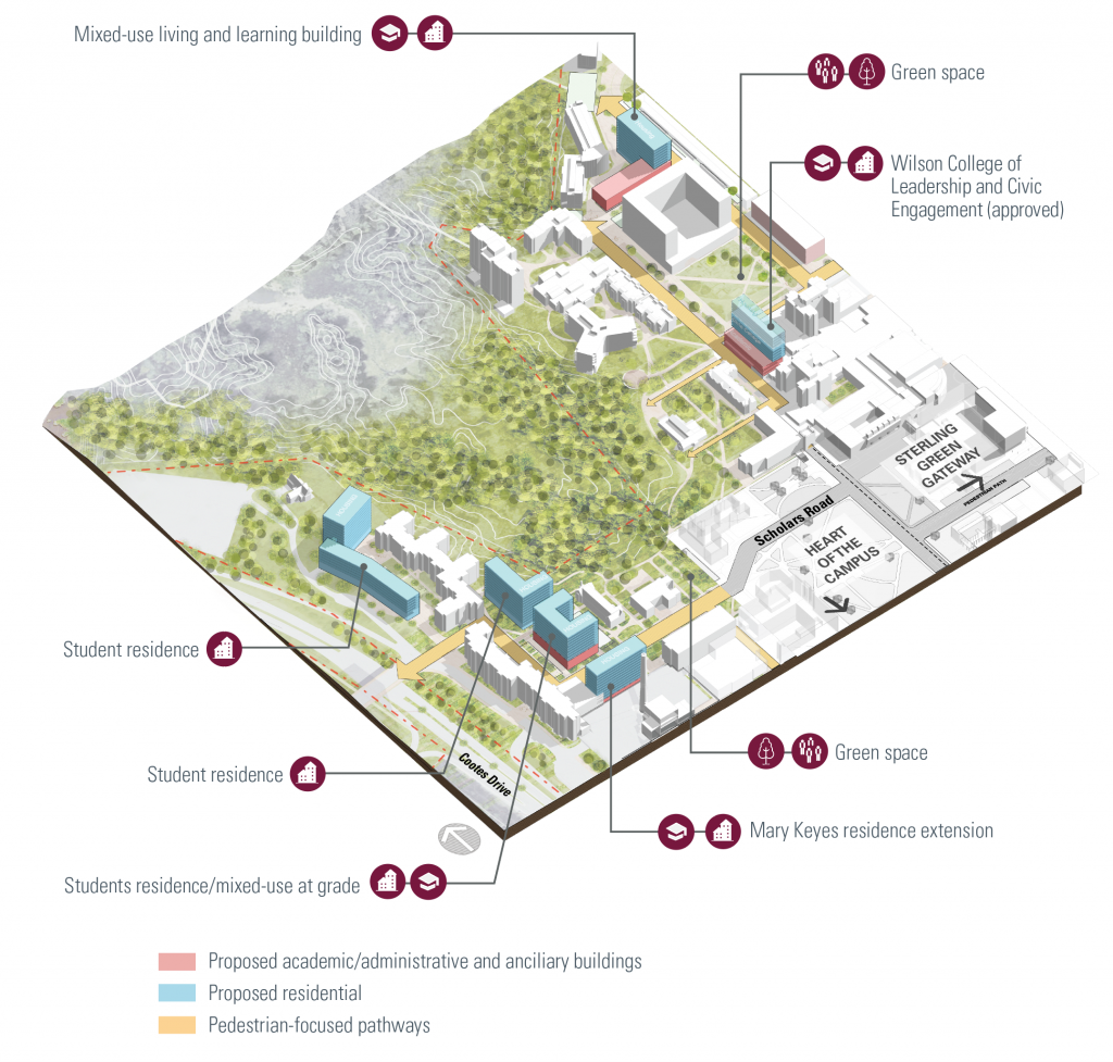
North and West Residence Quads
The Campus Plan proposes three key approaches to help meet the growing housing demand from students, faculty and staff. These include identifying opportunities for: mixed-use residences on campus that include academic programming or other supporting amenities, like the Peter George Centre for Living and Learning, housing nearby to campus that provides walkable access to campus, like Lincoln Alexander Hall, and housing along key transit routes that provide easy access to campus via sustainable transit options, like the 10 Bay Graduate Residence.
Consideration should be given to include housing for Indigenous students and equity-deserving groups.
On campus, the vision for residential neighbourhoods includes opportunities for new residences as well as renewal of older residence stock in the existing West and North Residence Quads. Housing opportunities can be further explored in the west campus and along Main Street West at the south edge of campus. This will help to reinforce the vibrant student community on campus. Mixed-use edifices, which include academic programing or other supporting facilities within the lower levels are strongly encouraged nearer to teaching and research hubs on campus.
To the west of the Arts Quad between Chester New Hall and Togo Salmon Hall, the new Wilson College of Leadership and Civic Engagement will provide a home to the recently announced leadership college and include housing accommodation above.
Three approaches to help meet housing demand from students, faculty and staff:
1. Mixed-use residences on campus (ex. Peter George Centre for Living and Learning)
2. Housing nearby residences walkable to campus (ex. Lincoln Alexander Hall)
3. Housing along key transit routes (ex. 10 Bay Graduate Residence)

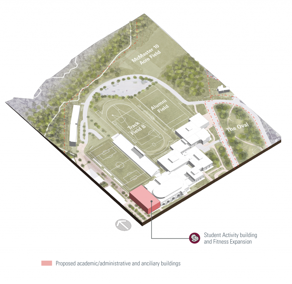
Athletics and Recreation
The athletics and recreation facilities built on campus have undergone extensive improvement in recent years with the new Student Hub and Pulse Gym addition on the west side of the David Brayley Athletic Centre, and the High-Performance Area and Turf Gym addition on the east side of the Ivor Wynne Centre. The Campus Plan proposes to concentrate on public realm and landscape enhancements in these areas. Student, staff, and visitor vehicles should be restricted to the edges of campus to promote pedestrian safety and the creation of places for people. Temporary gravel surface parking lots should be removed and naturalized along the top of the south bank of the ravine using native non-invasive plant species to protect the neighbouring natural areas of Cootes Paradise to the north. Trail heads can be more clearly marked and signage added to educate trail users on the appropriate use of trails and the habitat restoration efforts underway. The marshlands are owned and managed by the Royal Botanical Gardens, forming part of the UNESCO Niagara Escarpment Biosphere Reserve and the heart of the Cootes to Escarpment EcoPark System.
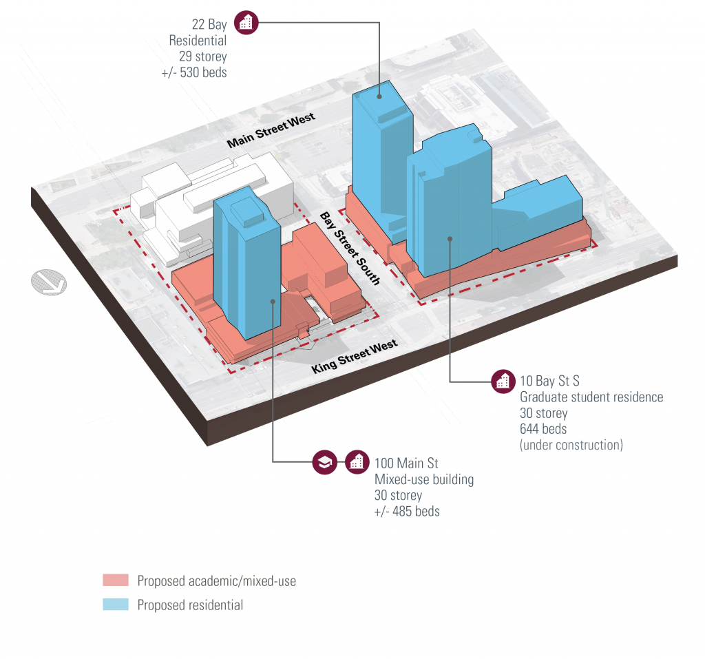
Downtown Hamilton Campus Locations
The Campus Plan proposes the development of additional residential accommodation in Downtown Hamilton, supplementing the additional supply which is proposed on and near campus. This aligns with one of the three housing strategies, notably providing residences along key transit routes. New university housing in downtown Hamilton could accommodate graduate students, faculty, staff, Indigenous communities and equity-deserving groups.
Although the campus itself is proposed as the primary location for new academic facilities, there is potential within the Downtown Hamilton sites, some of which are owned in partnership and would be developed as Public-Private Partnerships (P3), to integrate an element of academic programming in future proposals, particularly where this relates to facilities which would be open to the broader community, as well as expansion of existing Faculty of Health Sciences activities.

Burlington Campus
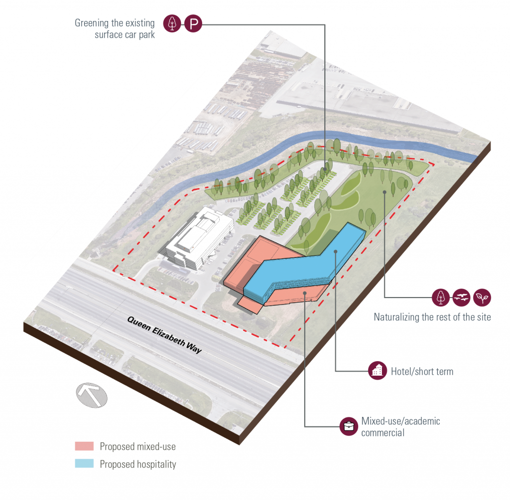
The Burlington satellite campus has growth potential and could be considered for complementary Faculty of Business programming and business-led partnerships in mixed-use spaces, providing opportunities for students to work directly with emerging businesses in start-up and incubator spaces. This could complement existing business partnerships at MIP, providing opportunities for interdisciplinary work between the Faculties of Business, Science and Engineering across a range of areas such as in cleantech. Ancillary use facilities such as a hotel / short-stay development could be considered along with related amenities like food & beverage, leisure, and workspace.
The university could also look at opportunities to work with the City of Burlington to review zoning laws, creating opportunities to diversify the potential uses at the Burlington Campus and consider complementary uses such as student accommodation. Alternative uses could include demonstration projects for McMaster, given the site’s prominent location along the QEW.
Efforts to naturalize the creek at the rear of the lot should also be considered as an opportunity to create enhanced outdoor features at this campus and protect the natural ecology of the site.